Heavy Construction With Digital Design Files
The design engineering profession is currently experiencing the start of a fundamental shift in the way infrastructure projects are designed and subsequently constructed. The same fundamental shift is reshaping both the land surveying profession and the heavy construction trades. What is this fundamental shift? The construction of infrastructure projects from digital design files.
In this first article on heavy construction with digital design files we will briefly consider the difference between the historical method of heavy construction projects and this modern method. We will then briefly discuss the technology driving these changes.
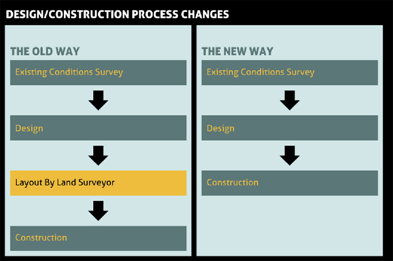
Comparison of Infrastructure Design & Construction Methods
In the traditional method of heavy construction the design engineering team takes a traditional survey deliverable representing existing conditions on the project site and creates a set of construction plans for the proposed infrastructure improvements. The construction plans are then utilized by a land surveyor to layout the location of the infrastructure improvement during construction. The land surveyor that prepares the survey deliverable used for the project design is often not the same surveyor that performs the construction layout.
The hardcopy signed plans are the governing contract documents in this traditional method of construction. The design engineering team may not provide digital files for use in construction, and if they do, these files are often provided with no warranty or guarantee. The construction team and surveyor performing construction layout use any digital files provided by the design team at their own risk.
In the modern method of heavy construction the design engineering team provides digital design files that are used for multiple phases of construction. These digital design files may be used by a land surveyor for some limited layout of infrastructure using traditional survey stakes, but more often the files are used for automated machine guidance or machine control.
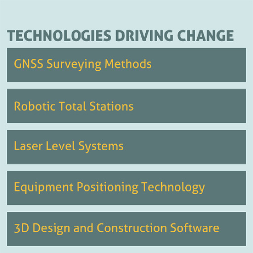
Technologies Driving Change
What are the technologies driving this change? They include the following:
- GNSS satellite surveying methods.
- Robotic total station surveying methods.
- Laser level and linked laser level systems.
- Positioning of heavy equipment using GNSS/Robotic Total Stations/Laser Level Systems.
- 3D design and 3D construction software.
Many of these technologies have appeared in the last 10 or 20 years. Over this period the quality of the technology has improved while the price has fallen. How common is this technology on the heavy construction site? It is now rare to visit a construction site without the presence of GNSS receivers on heavy equipment or in the hands of the contractor’s grade setter.
The CLSA Central Valley Chapter Construction Committee has started work to identify and provide solutions to the challenges that arise from the use of digital design files in heavy construction. In our next article in this column we will review some of the committee’s recent work.